Home » Products » Topcon » Machine control » MM GPS
mmGPS
Millimeter GPS+ transforms GPS into the perfect tool for blue-topping and other fine tolerance work. With Millimeter GPS+, the days of lost productivity, using stringlines or running manually off of hubs, are over.
Features & Benefits
- Patented technology combines advantages of laser and GPS
- Large working range: up to 8000’ horizontal & 136’ vertical
- Works with existing Topcon GPS+ systems
- Control multiple machines and rovers at the same time
- Very user friendly
- Up to 300% more accurate than standard GPS
- Increased productivity – fewer passes needed to reach finish grade
- Lower investment – one system works for rough & finish grade
- Grade to tighter tolerances and eliminate high-cost material overruns
- Finish grade 24/7 even with minimal satellite coverage
- Works on Motor Graders, Dozers, Dirt Trimmers, Milling Machines, Asphalt Pavers & Concrete Pavers
- mmGPS option with Pocket 3D
Millimeter GPS+ combines the advantages of laser (multi-user & high vertical accuracy) with GPS (multi-user & 3D) into one ver- satile and easy to use system. This patented technology improves grading accuracy up to 300% over existing 3D-GPS machine systems.
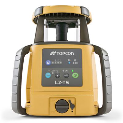
Unlike any other laser technology, the LZ-T5 transmitter sends out a wall of light 33’ tall and up to 1000’ in diameter. Simply add the PZS-MC machine control sensor or PZS-1 rover sensor to your existing GPS+ system, and watch your GPS vertical accuracy shrink down to numbers you never imagined before. Need more coverage? You can link up to four LZ-T5 transmitters for a total of 4000’ horizontally and 132’ vertically. Unlike with total stations, multiple machines and man rovers run off one transmitter, there is no limit!
Millimeter GPS can also be utilized with Pocket 3D using the same LZ-T5 transmitters with the PZS-1 sensor on the rover to provide higher vertical accuracy over traditional GPS rover systems. The machine and rover can work simultaneously off the same LZ-T5 transmitter providing fast and accurate elevations checks on the rover with Millimeter GPS.
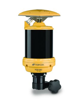
PZS-MC Sensor
The PZS-MC sensor replaces the machine-mounted GPS antenna. The PZS-MC sensor combines the MC-A1 GPS antenna with laser sensor technology into a total package. LazerZoneTM technology allows the sensor to detect up to four different LZ-T5 laser transmitters for increased range. The sensor attaches to a GPS vibration pole on the machine blade, and cables connect the receiver to the MC-R3 Receiver Box for sending corrections to the 9168 control box.
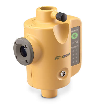
PZS-1 Sensor and GPS+ Receiver (optional)
The PZS-1 sensor instantly computes precise vertical information from the LZ-T5 laser transmitter. Using Lazer Zone technology, the PZS-1 automatically determines elevation based on jobsite control. Mounting the PZS-1 to a range pole and attaching a GPS+ receiver allows the sensor to receive the LZ-T5 laser signal and wirelessly transmit data to the receiver.
PZS-MC Sensor
The PZS-MC sensor replaces the machine-mounted GPS antenna. The PZS-MC sensor combines the MC-A1 GPS antenna with laser sensor technology into a total package. LazerZoneTM technology allows the sensor to detect up to four different LZ-T5 laser transmitters for increased range. The sensor attaches to a GPS vibration pole on the machine blade, and cables connect the receiver to the MC-R3 Receiver Box for sending corrections to the 9168 control bo
Grade Management Software Solution
Optional field software for all control applications, Pocket-3D and MAGNET Field Site assists superintendents, operators, or grade checkers when staking or checking grade on a site. This software runs on a portable hand-held controller and uses files common with other equipment on the job site, allowing multiple users to work at the same time. This software is required for some mmGPS operations.
Using a grade management system software on a portable hand-held controller, you can:
- Set up the Base Station, the mmGPS Transmitter, and the mmGPS Rover
- Create and edit Control Point files and Design Surface files
- Create and edit Machine Configuration files and radio configuration files
- Create and edit Point files and Linework files
- Import and export files
- Perform stakeouts and grade checks
- Perform topographic surveys
- Set up machine files for mmGPS equipment
- Set up the PZS-MC sensor
- Check the height of the transmitter
- View a history of surface activity